Sea Level Monitoring
TSU/MAB Coastal Hazards Project
FOR ARCHIVE - CARIBE EWS - WG2: Tsunami Hazard Assessment
Chair: Nicolas Arcos (USA)
Vice-Chair: Alberto López-Venegas (Puerto Rico, USA)
Working Group Two: Tsunami Hazard Assessment
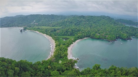
The Working Group 2 (WG2) on Tsunami Hazard Assessment is one of four main working groups within the ICG/CARIBE-EWS. Its primary objective is to advise the ICG on the identification and characterization of coastal hazards, their assessment and the required modeling. Among the functions of this working group is to assist the ICG/CARIBE-EWS Member States on assessing their tsunami threat.
To fulfill this task, WG2 has reviewed and evaluated methods and data sets to determine the seismic potential within the Caribbean region and to model seismic scenarios to help assess the tsunami threat.
Since determining the hazards depend on coastal topography and bathymetry, the WG2 has performed a variety of surveys within the Member States to inquire the availability of such data within their countries and help them develop plans for the ultimate goal of creating tsunami evacuation maps.
Below is a selection of relevant WG2 products:
Scientific Papers:
A Collaborative Effort Between Caribbean States for Tsunami Numerical Modeling: Case Study CaribeWave15. Chacón-Barrantes, S., López-Venegas, A., Sánchez-Escobar, R. and Luque-Vergara, N., Pure Appl. Geophys. (2017).https://doi.org/10.1007/s00024-017-1687-7 (Available to read online at http://rdcu.be/xBC1)
Nations work together to size up Caribbean tsunami hazards. López-Venegas, A. M., S. E. Chacón-Barrantes, N. Zamora, and J. Macías (2018), Eos, 99. https://doi.org/10.1029/2018EO105609. Published on 04 October 2018
Posters in Scientific Meetings
- American Geophysical Union 2015
- Tsunamis from Tectonic Sources along Caribbean Plate Boundaries. López, A. M., Chacón, S., Zamora, N., Audemard, F.A., Dondin, F., Clouard, V., Løvholt, F., Harbitz, C., Vanacore, E.A., Huérfano, V., 2015 AGU Fall Meeting, Abstract T11E-2942, http://abstractsearch.agu.org/meetings/2015/FM/T11E-2942.html
-
American Geophysical Union 2016
-
Numerical Simulation of Several Tectonic Tsunami Sources at the Caribbean Basin. Chacón-Barrantes, S.; López-Venegas, Alberto; Macías, Jorge; Zamora, Natalia; Moore, Christopher; Llorente, Miguel, 2016AGU Fall Meeting, Abstract NH43A-1799, http://abstractsearch.agu.org/meetings/2016/FM/NH43A-1799.html
American Geophysical Union 2018
Caribbean and Adjacent Regions Tsunami Sources and Models (CATSAM) Map Viewer. Arcos, N., Chacon-Barrantes, S., Varner, J., Lopez, A.https://agu.confex.com/agu/fm18/mediafile/Handout/Paper368231/Poster_201811229.pdf
Surveys on Availability of Bathymetric Data and Tsunami Evacuation Maps
- Survey to gauge availability of bathymetry, inundation and evacuation maps for the caribbean basin. Report is available to download here.
- Survey to determine the needs for generating tsunami evacuation and inundation maps for ICG/CARIBE-EWS member states. Report is available to download here, and presentation is available here.
- Minimum bathymetric requirements for modeling of coastal hazards available here Webmap
Since 2011, UNESCO - Intergovernmental Oceanographic Commission (IOC) Experts Meetings and CaribeWave exercises have resulted in a variety of tsunami models of credible scenarios that would impact the Caribbean and adjacent regions. During the 12th Session of the ICG/CARIBE-EWS in Costa Rica on 10-12 May 2017, a formal recommendation was adopted for Working Group 2 (Hazard Assessment) to compile the aforementioned tsunami scenarios with additional parameters such as tsunami energy plots and NOAA/NCEI historical tsunami data. In response to this recommendation, the Caribbean and Adjacent Regions Tsunami Sources and Models (CATSAM) map viewer was developed to more easily identify potential tsunami sources. CATSAM is intended to provide modelers and hazard assessment professionals with an understanding of the UNESCO/IOC led tsunami modeling efforts, as well as how those efforts overlap with the Global Historical Tsunami Database developed and maintained by NOAA’s National Centers for Environmental Information (NCEI) and co-located World Data Service (WDS) for Geophysics. The product is not meant to identify all tsunami sources in the region, just those identified by experts at UNESCO/IOC led meetings, as well as historically observed. At the 13th Session of the ICG/CARIBE-EWS in Curacao on 24-27 April 2018, CATSAM was presented and recommended for use by Member States. CATSAM webmap is available here.
WG2 annual reports
Reports summarizing WG2 activities and products are presented at annual ICG/CARIBE-EWS Sessions. The following list shows the most recent reports presented.
- 2014-2015 presentation available here and report available here.
- 2015-2016 presentation available here and report available here.
- 2016-2017 report available here.
- 2017-2018 presentation available here and report available here.
Support to IOC Experts Meetings
Under the auspices of IOC/UNESCO, a number of Experts Meetings on Tsunami Sources were carried out to review current tectonics of selected regions within the Caribbean basin and evaluate their tsunami potential. The selected areas within the Caribbean consisted of Northern, Honduras, Southern Dominican Republic, and Central America. These meetings have been fundamental in bringing experts of tsunami science together with the ultimate goal of increasing tsunami preparedness within the region. These meetings sought to identify credible sources of tsunamis that could significantly impact the mentioned countries and regions, that can be used for tsunami modeling, evacuation mapping, planning and exercises. In each case the scenarios were defined by a group of experts on seismology, tsunamis and tsunami modeling.
Scenarios were based on historical events and/or tectonic and geodetic. Although some scenarios may pose a low probability occurrence, they are still taken into consideration for preparedness purposes.
Experts Meeting Workshop on Tsunami Modeling and Mitigation. 1 - 3 December 2014, Cartagena de Indias, Colombia
In order to develop a strategy to homogenize the procedures for the creation of evacuation maps applicable to the Caribbean region, a group of experts met to discuss the current state of knowledge of Caribbean tectonics and seismology, tsunami numerical modelling and their validations, evacuation strategies, and real-time forecasting of tsunami effects.
The Final Report of this meeting is available here.
Experts Meeting on Sources of tsunamis in the Caribbean with possibility to impact the southern coast of the Dominican Republic. 6 - 7 May 2016, Santo Domingo, Dominican Republic
The aim of this meeting, jointly organised by the Universidad Autonoma de Santo Domingo (UASD) and UNESCO’s IOC, was to identify credible seismic sources in the Caribbean with enough potential to produce tsunamis that may affect the southern coast of the Dominican Republic.
The Final Report of this meeting is available at WR276
Experts Meeting “Tsunami Hazard in Central America: Historical Events and Potential Sources” 23 - 24 June 2016, San José, Costa Rica
The aim of this meeting was the identification of credible sources of tsunamis that could significantly impact the Pacific and Caribbean Coasts of Central America that can be used for tsunami modelling, evacuation mapping, planning and exercises.
Pilot Course: Preparación Tsunami Preparedness: Tsunami Evacuation Maps, Plans, And Procedures (Tempp). 29 February - 3 March 2016, Comayagüela, F.M, Honduras
The “Essential Tsunami Preparedness: Developing Tsunami Evacuation Maps, Plans, And Procedures” course trains countries on how to produce reliable and practical, science-based, community-driven tsunami evacuation maps. The Course is globally applicable, and employs standardized tools and methodologies, and best practices. The Pilot Course, conducted in Honduras in 2015-2016, consisted of a series of five inter-related training workshops covering topics of preparing community-owned evacuation plans, maps, and procedures focused and applied to two Honduran communities .
Experts Meeting Earthquake and Tsunami Hazard in Northern Haiti: Historical Events and Potential Sources. 10 - 11 July 2013, Port au Prince, Haiti
The purpose of this technical scientific meeting was to discuss the source of the 1842 event as well as other sources of earthquakes and tsunamis along the northern coast of Hispaniola that could impact the northern coast of Haiti.
The Final Report of this Meeting is available at IOC/2013/WR/255
About the Tsunami Programme
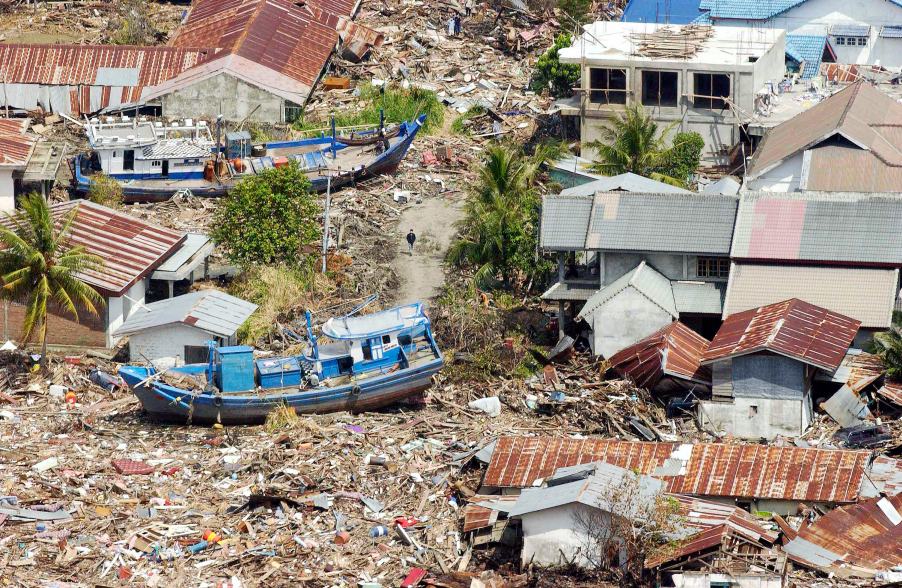
The Indonesian coast, between Banda Aceh and Meulaboh, after the earthquake and the tsunami of 26 December 2004. Photo by Evan Schneider © UN Photo
UNESCO supports Member States in improving capabilities for tsunami risk assessment, implementing early warning systems and enhancing preparedness of communities at risk. UNESCO works closely with national institutions and promotes inter-institutional and regional cooperation. Specialized regional centers provide tsunami information that, together with national analysis, is the basis of the warnings issued for the public. In addition, UNESCO promotes community-based approaches in the development of response plans and awareness campaigns which strongly involve education institutions and end-users.
Upcoming Events
5 - 9 August 2024
Male
7 August 2024
19 August 2024
19 - 30 August 2024
Chile