Sea Level Monitoring
TSU/MAB Coastal Hazards Project
NOAA/NOS Tsunami water level data products available over the GTS
On August 7, 2013, NOAA’s National Ocean Service (NOS) Center for Operational Oceanographic Products and Services (CO-OPS) released new data products over the Global Telecommunication System (GTS). Included in this release is a set of one-minute water level data products, formatted into Character form for the Representation and EXchange of data (CREX) messages. CREX is table-driven code that follows World Meteorological Organization definitions, and allows a large set of data to be succinctly formatted into a human-readable message. One-minute water level data from each CO-OPS station is transmitted via GOES, Iridium, or phone/IP, and ingested into CO-OPS systems. During this ingestion process, the data are organized into regionalized CREX bulletins and disseminated over the GTS. WMO headers for these bulletins are:
SZNT31 KWBC (AtlanticCoast)
SZGX32 KWBC (GulfCoast)
SZCA33 KWBC (CaribbeanIslands)
SZPZ34 KWBC (PacificCoast)
SZAK35 KWBC (AlaskaCoast)
SZHW36 KWBC (Hawaii)
SZPA37 KWBC (Pacific Islands)
These products address a need for high-frequency sea level data collected at stations outside of the GOES footprint. CO-OPS plans to also develop BUFR products (the binary counterpart to CREX) in the near future.
For more information on NOS/CO-OPS, please contact This email address is being protected from spambots. You need JavaScript enabled to view it.
Tsunami Safety Course for Tourism, Hotel and Security in the Dominican Republic
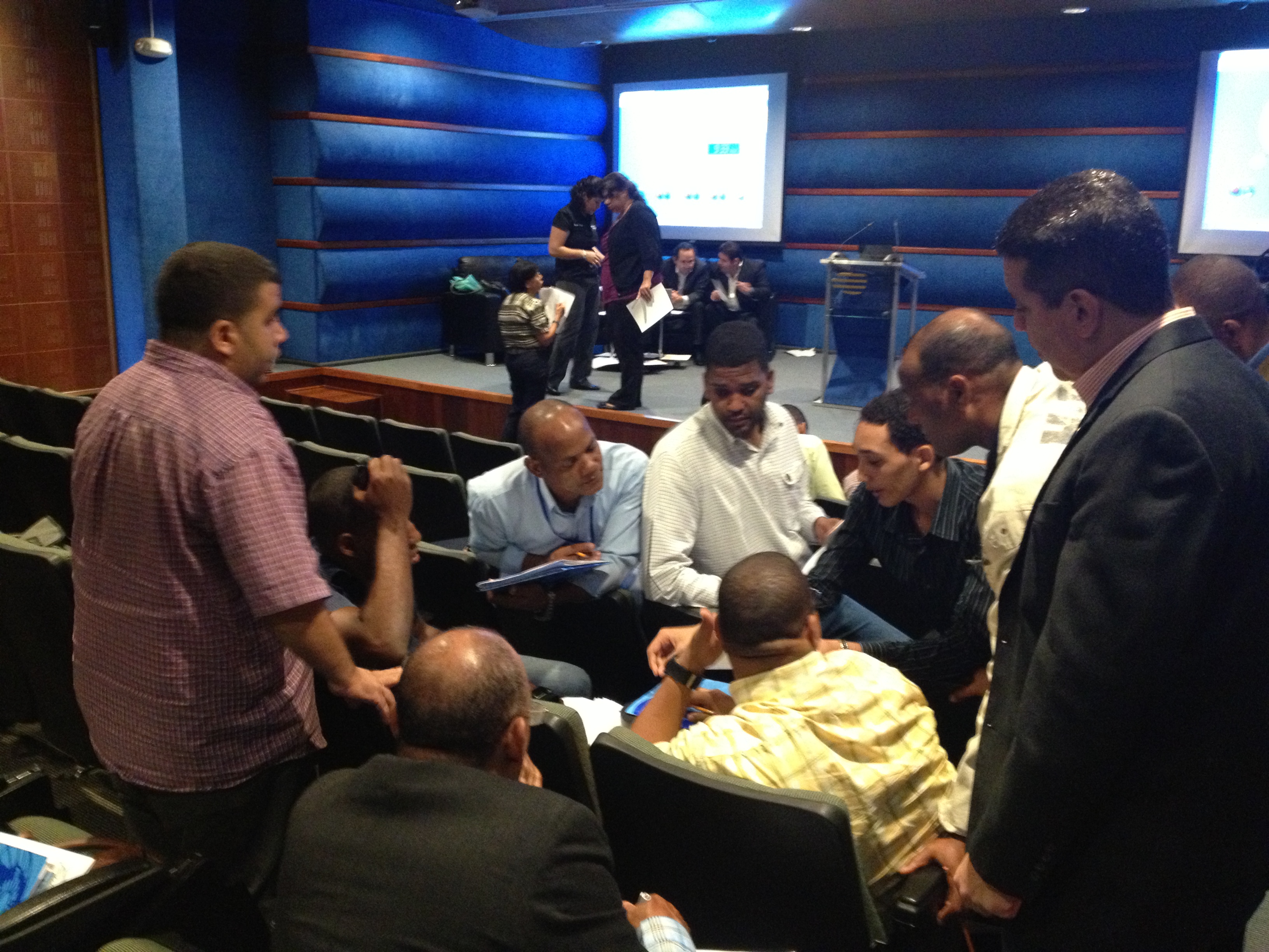 On July 29-31, 2013 Global Foundation for Democracy and Development (FUNGLODE) of the Dominican Republic hosted the first Tsunami Safety Course tailored for the Tourism, Hotel and Security industries. Forty people participated in this event which was organized by its Global Institute for Higher Studies in Social Sciences and delivered in Santo Domingo. The objective was to provide the tourism and hotel sectors with basic knowledge on tsunamis, the national response protocols and elements for their preparedness and response plans. The format of the course included lectures as well as hands on exercises for the development of plans and responding to local and regional tsunamis. Josefina Reynoso of FUNGLODE and General Luis Luna Paulino, Chair of the National Emergency Commission emphasized that although tsunamis occur infrequently, the impact could be devastating and the task to prepare for such an event has to be ongoing. Dominican Republic has been affected by local and distant tsunamis. In 1946 two tsunamis are reported to have caused the death of over 1800 people along its northern coast. Currently, the county receives over 4 million visitors a year, 1.5 of which are US citizens. They are mostly attracted by its beautiful beaches where almost the entire tourism infrastructure is concentrated. The NWS Caribbean Tsunami Warning Program (CTWP), Puerto Rico Seismic Network (PRSN) and UNESCO IOC Tsunami Program developed the syllabus and coordinated with the local experts and stakeholders from the Civil Defense, National Meteorological Office, the Autonomous University of Santo Domingo, Ministry of Environment and Global Matrix Corporation for the organization and delivery of the course. Given the positive feedback, FUNGLODE has already requested the CTWP, UNESCO and PRSN to help co-organize additional courses in the summer of 2014 with deliveries in key tourist areas. The syllabus and material used for this course could also serve as the base for other trainings for the tourism sector.
PTWS South America: Launch of the Regional Early Tsunami Warning Protocol and its virtual platform
 In order to strengthen the efficient and effective interconnection among the four warning systems that make up the southeast Pacific region, UNESCO, in coordination with the Permanent Commission for the South Pacific (CPPS), the UNESCO Intergovernmental Oceanographic Commission and the national tsunami warning systems of Chile, Colombia, Ecuador and Peru, has promoted the elaboration of the document “Standardised Operating Procedures for Early Tsunami Warning Communications in the Southeast Pacific”.
The document was prepared with the support of the Seventh Plan of Action of the Disaster Preparedness Programme (DIPECHO) for South America of the South American Office of the European Community Humanitarian Aid and Civil Protection Directorate General (DG-ECHO).
This initiative was aimed at strengthening national early tsunami warning systems in order to generate a regional system through shared strategies and standardised procedures at the regional, national and local levels. The document was prepared with to the contribution of national institutions within the tsunami warning systems, such as oceanographic institutes, seismological services and national disaster risk management departments.
The Virtual Platform of the Regional Early Tsunami Warning System is a tool that has two purposes. The first is to act as a platform for the exchange of technical and educational information regarding tsunamis in the southeast Pacific region. The second purpose is to construct a virtual space for communications among the authorities responsible for the Tsunami Warning Systems in each of the four countries, using the Regional Communications Protocol as a guide.
The CPPS has developed the Regional System’s Virtual Platform, and it will be responsible for hosting and keeping this platform online and up-to-date. At the same time, it will make the Platform available for communications exercises related to the Protocol, to be carried out by the Regional Coordinator of the Southeast Pacific Early Tsunami Warning System.
Caribbean Tsunami and other Coastal Hazards meeting recognizes increased regional capabilities.

The 8th session of the Intergovernmental Coordination Group for the Tsunami and Other Coastal Hazards Warning System for the Caribbean and Adjacent Regions (ICG/CARIBE EWS-VIII) was held in Port of Spain, Trinidad & Tobago, from 29 April to 1 May 2013, hosted by the Ministry of National Security through the Office of Disaster Preparedness and Management (ODPM). The meeting was attended by 56 participants from 18 Caribbean countries and four observer organizations (United Nations Development Programme - UNDP, Caribbean Disaster Management Agency - CDEMA, Puerto Rico Seismic Network – PRSN and the University of the West Indies Seismic Research Center - SRC). The session recognized the increased regional capabilities for tsunami coordination, alerting and monitoring, bringing it up to 94% of National Contacts and Warning Focal Points having been designated and 85% implementation of the seismic network and 44% of the sea level network plans. The newly established Caribbean Tsunami Information Center (CTIC), hosted by the Department of Emergency Management (DEM) of the Government of Barbados was tasked with holding at least two Standard Operating Procedures (SOPs) trainings during 2013. The Member States urged again the US to continue with its phased approach towards the establishment of a Caribbean Tsunami Warning Center in Mayagüez, Puerto Rico. The evaluation of the CARIBE WAVE 13 exercise demonstrated the usefulness of these exercises and the interest of Member States in further testing the Enhanced PTWC products for the region. As a consequence, the plenary decided to hold annual CARIBE WAVE exercises to regularly test tsunami preparedness in the Caribbean, with the next one being coordinated for March 26, 2014. The IX Session is to be hosted by the Government of the US Virgin Islands on the island of St. Thomas in May, 2014.
New Omani sea level stations strengthen tsunami warning systems in the Western Indian Ocean.
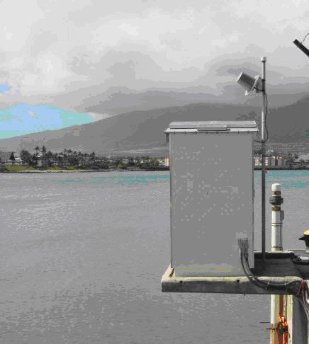
 The Directorate General of Meteorology and Air Navigation/Public Authority for Civil Aviation (DGMAN/PACA) of Oman has installed seven new sea level stations along the coast of the Sultanate with the assistance of UNESCO's Intergovernmental Oceanographic Commission (IOC-UNESCO). The stations are functional and providing data streams through the IOC-UNESCO Sea Level Station Monitoring Facility via GTS (Global Telecommunication System), a monitoring service for real time sea level measuring stations.
IOC-UNESCO has been closely working with the Sultanate of Oman, providing technical support and guidance to assist in the design and establishment of its own National Multi Hazard Early Warning System (NMHEWS) including for tsunami and other sea-level related hazards. The new sea level stations and the national early warning system will serve to strengthen the Indian Ocean Tsunami Warning and Mitigation System (IOTWS) by providing a much more complete coverage of the North Western Indian Ocean including Oman Sea.
More Articles...
- ITIC – UNESCO Regional Training Workshop on Strengthening Tsunami Warning and Emergency Response Standard Operating Procedures (SOPs).
- The Ministry of Education of Chile reproduces the educational modules: “Tsunami risk management in educational institutions”, developed by UNESCO for nursery, primary and secondary school education
- Exercise Indian Ocean Wave 2011 heralds the commencement of Regional Tsunami Service Providers operations in the Indian Ocean
- Regional Workshop on Standard Operating Procedures for Tsunami Warning and Emergency Response held in Jakarta
About the Tsunami Programme
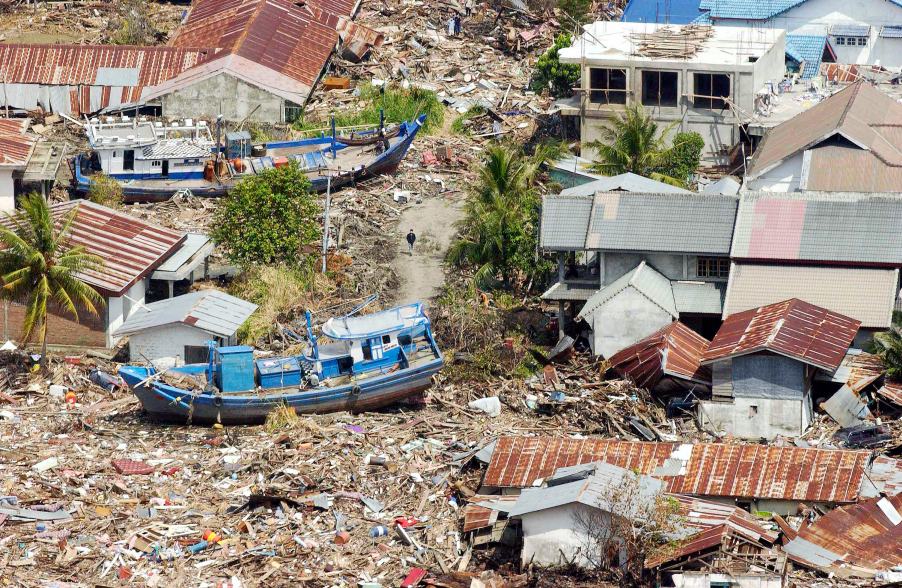
The Indonesian coast, between Banda Aceh and Meulaboh, after the earthquake and the tsunami of 26 December 2004. Photo by Evan Schneider © UN Photo
UNESCO supports Member States in improving capabilities for tsunami risk assessment, implementing early warning systems and enhancing preparedness of communities at risk. UNESCO works closely with national institutions and promotes inter-institutional and regional cooperation. Specialized regional centers provide tsunami information that, together with national analysis, is the basis of the warnings issued for the public. In addition, UNESCO promotes community-based approaches in the development of response plans and awareness campaigns which strongly involve education institutions and end-users.
Upcoming Events
7 August 2024
19 August 2024
19 - 30 August 2024
Chile