Sea Level Monitoring
TSU/MAB Coastal Hazards Project
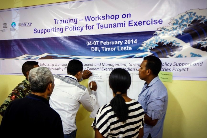
Development and Strengthening of Tsunami Exercise Policies in Bangladesh, Myanmar and Timor Leste
The IOC UNESCO project on “Enhancing Tsunami Risk Assessment and Management, Strengthening Policy Support and Developing Guidelines for Tsunami Exercises in Indian Ocean Countries” is being jointly implemented by the Intergovernmental Coordination Group for the Indian Ocean Tsunami Warning and Mitigation System (ICG/IOTWS) and the Indian Ocean Tsunami Information Centre (IOTIC). The project aims to support the development and strengthening of tsunami exercise policies in the three pilot countries of Bangladesh, Myanmar and Timor Leste. The project is supported through a grant from the United Nations Economic and Social Commission for Asia Pacific (UNESCAP) Trust Fund for Tsunami, Disaster and Climate Preparedness.
In each pilot country, a stock taking survey designed to assess disaster risk reduction policies relating to tsunami has been undertaken. The survey addresses tsunami risk, hazard, exercise activities and emergency response standard operating procedures via consultation with two main stakeholders in each country.
Training modules on Policy Support and Guidelines for Tsunami Exercises were developed by an expert team comprised of researchers, scientists, government representatives and Disaster Risk Reduction specialists from Indonesia, Malaysia, Pakistan, Sri Lanka and New Zealand. Based on IOC Manuals and Guides Series No. 52: “Tsunami Risk Assessment and Mitigation for the Indian Ocean”, and No. 58: “How to Plan, Conduct and Evaluate Tsunami Exercises”, two training modules were developed, which will be implemented in two separate workshops in three pilot countries. The first training module focuses on the development of national policies to support a sustainable tsunami exercise programme. The second module focuses on how to plan and implement tsunami exercises. The training workshops will assist the three target countries to prepare and actively participate in the upcoming Indian Ocean Wave Exercise scheduled to take place in September 2014. Workshops on the first training module have been undertaken in Dhaka, Bangladesh in November 2013 and in Dili, Timor Leste in February 2014.
Le Brésil, Monaco, l'Union européenne et Saint-Vincent-et-les-Grenadines contribuent au renforcement du réseau d'observation du niveau de la mer pour surveiller les tsunamis et autres risques côtiers dans les Caraïbes.

Dans les 500 dernières années, plus de 75 tsunamis ont été rapportés dans les Caraïbes et les régions adjacentes. Depuis 1842, 3 446 personnes auraient péri à cause de ces vagues meurtrières. Le tsunami généré par le séisme de 2010 en Haïti a réclamé beaucoup de vies, mais les événements les plus dévastateurs, récemment, étaient les tsunamis de 1946 en République Dominicaine, avec au moins 1 800 victimes.
Les événements connus les plus destructeurs ont eu lieu en: 1692 à Port Royal, en Jamaïque; en 1770 à Port-au-Prince, en Haïti, en 1842 à Port-de-Paix et Cap-Haïtien; en 1867 à Charlotte Amalie, dans les Îles Vierges des États-Unis; en 1882 aux Îles San Blas et à Panama, en 1918 aux États-Unis et à Porto Rico et enfin en 1946 à Matanzas, en République dominicaine.
Depuis, il y a eu une augmentation explosive de résidents, de visiteurs, d'infrastructures et de l'activité économique le long des côtes des Caraïbes, ce qui a pour effet d'augmenter le potentiel de pertes humaines et économiques.
Pour les zones sujettes aux tsunamis, l'expérience dans la coordination du système d'alerte aux tsunamis de l'UNESCO, dans le Pacifique, a montré qu'un bon réseau de stations de mesure du niveau de la mer aident à fournir des alertes précoces avec précision et en temps opportun. C'est dans cet esprit et avec le soutien du Brésil, de Monaco, de l'Union européenne, et de Saint-Vincent-et-les-Grenadines, que la Commission océanographique intergouvernementale (COI ) de l'UNESCO a commandé six (6) stations de mesure du niveau de la mer flambant neuves, pour Haïti (2) , les Îles Caïmans, le Guatemala, Saint-Vincent-et-les Grenadines et Saint-Christophe-et-Niévès qui sont maintenant opérationnelles et livrent des données à travers le Service de Station de mesure du niveau de la mer de la COI.
L'UNESCO et la COI sont engagés à poursuivre le développement de systèmes d'alerte précoce de bout en bout des risques côtiers, de sauver des vies et d'améliorer la préparation aux tsunamis dans les Caraïbes.
Formation aux Procédures opérationnelles normales pour les Tsunamis (SOP) dans les Caraïbes.
Le Centre international d'information sur les tsunamis (ITIC), en collaboration avec le Centre![BG Elton Lewis, Director Virgin Islands Territorial Emergency Management Agency [right] receiving his certificate of completion from Ms. Alison Brome (Interim CTIC Director)](images/BG%20Elton%20Lewis%20Director%20Virgin%20Islands%20Territorial%20Emergency%20Management%20Agency%20right%20receiving%20his%20certificate%20of%20completion%20from%20Ms.%20Alison%20Brome%20Interim%20CTIC%20Director.jpg "BG Elton Lewis, Director Virgin Islands Territorial Emergency Management Agency [right] receiving his certificate of completion from Ms. Alison Brome (Interim CTIC Director)") d'information sur les tsunamis dans les caraïbes (CTIC) et le Programme d'alerte aux tsunamis dans les Caraïbes ( CTWP ) des États-Unis , avec le soutien de la Commission océanographique intergouvernementale de l'UNESCO et le Programme des Nations Unies pour le développement (PNUD ) Bureau pour la Barbade et les pays de l' Organisation des États des Caraïbes orientales (OECO), a travers son projet Renforcer la résilience et réduire la vulnérabilité des Caraïbes (ERC) ont récemment organisé un atelier sur le renforcement des Procédures opérationnelles normales pour l'alerte aux tsunamis et l'intervention d'urgence , le 4 - 8 Novembre 2013.
d'information sur les tsunamis dans les caraïbes (CTIC) et le Programme d'alerte aux tsunamis dans les Caraïbes ( CTWP ) des États-Unis , avec le soutien de la Commission océanographique intergouvernementale de l'UNESCO et le Programme des Nations Unies pour le développement (PNUD ) Bureau pour la Barbade et les pays de l' Organisation des États des Caraïbes orientales (OECO), a travers son projet Renforcer la résilience et réduire la vulnérabilité des Caraïbes (ERC) ont récemment organisé un atelier sur le renforcement des Procédures opérationnelles normales pour l'alerte aux tsunamis et l'intervention d'urgence , le 4 - 8 Novembre 2013.
Cet atelier de formation est la première activité importante après la récente mise en place du CTIC. Elle a ciblée les points focaux pour l'alerte aux tsunamis (TWFP) et les organisations d'intervention d'urgence en cas de tsunami (TER) dans dix (10) pays de la région des Caraïbes et les régions adjacentes. L'atelier de formation d'une semaine à couvert des sujets essentiels impliqués dans l'alerte au tsunami de bout en bout, y compris la surveillance des événements et la détection, l'évaluation de la menace, la diffusion de l'alerte, l'intervention d'urgence, l'évacuation, et l'action publique. La formation insiste également sur l'établisment d'un système d'alerte aux tsunamis solide, et des Procédures opérationnelles normales (SOP) et d'intervention d'urgence comme une condition essentielle pour une alerte au tsunami de bout en bout avec succès .
")
Il a été rappelé aux participants qu'un système d'alerte aux tsunamis n'est efficace que lorsque toutes les personnes dans les communautés côtières vulnérables sont prêts à réagir de manière appropriée et en temps opportun lors de la identification d'un tsunami potentiellement destructeur. Relever ce défi nécessite des équipes de surveillance jour et nuit avec des flux de données rapides, d'alerte en temps réel et, ainsi que des communautés préparées, un système solide de gestion des urgences et la coopération étroite et efficace entre toutes les parties prenantes.
![Mr. Keithley Meade Director Meteorological Office of Antigua and Barbuda [right] receiving his certificate of completion from Dr. Laura Kong (ITIC)](images/Mr.%20Keithley%20Meade%20Director%20Meteorological%20Office%20of%20Antigua%20and%20Barbuda%20right%20receiving%20his%20certificate%20of%20completion%20from%20Dr.%20Laura%20Kong%20ITIC.jpg "Mr. Keithley Meade Director Meteorological Office of Antigua and Barbuda [right] receiving his certificate of completion from Dr. Laura Kong (ITIC)")
Cet atelier de formation sera reproduit à la Barbade au cours de la semaine du 18 au 22 Novembre 2013 pour les TWFP et TER du sud de la Caraïbe, pour 10 autres pays. L'ensemble de ces formations obtiendront la constitution d'environ 100 agents des Caraïbes prêts a se préparer pour et à faire face aux urgences du tsunami.
Plus d'informations: Bernardo Aliaga, SC/COI, Cette adresse e-mail est protégée contre les robots spammeurs. Vous devez activer le JavaScript pour la visualiser.
Collection of Eyewitness Interviews and Historical Documents on the 1945 Makran Tsunami
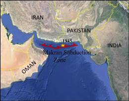 A meeting of the IOC UNESCO project on “Communicating the effects of the 1945 Makran tsunami to increase awareness and preparedness of tsunami hazards in the Makran region” was held in Muscat, Oman from 20-24 October 2013. The meeting reviewed the collection of eyewitness interviews and historical documents on the tsunami that have been obtained during missions to Oman, Pakistan, Iran and India, and formulated plans for further work. The highest priorities for the new activities are 1) interviews in the Indus Delta near Karachi in Pakistan where it appears the majority of fatalities took place and 2) follow-up interviews in Pasni, Pakistan to constrain the timing of the old port sliding into the sea and to explore whether this slide could account for the late, large “second” wave. The collection of eyewitness interviews and historical documents as well as summary material for coastal communities and policy makers will be made available on the Indian Ocean Tsunami Information Center website (iotic.ioc-unesco.org) in 2014.
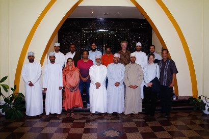 Funding for the project is provided by the ESCAP administered Trust Fund on Tsunami, Disaster and Climate Preparedness in the Indian Ocean and Southeast Asian Countries. The Directorate General of Meteorology and Air Navigation (DGMAN) hosted the meeting. Participants included seven tsunami researchers from the Makran countries, a researcher from the United States, six observers from the Oman Forecasting Centre at DGMAN and three representatives from the IOC UNESCO Secretariat.
Regional Workshop on Standard Operating Procedures for Tsunami Warning and Emergency Response for Northern and Eastern Indian Ocean Countries
A regional training workshop on tsunami warning and emergency response SOPs for Northern and Eastern Indian Ocean countries was held at the Mercure Hotel in Jakarta, Indonesia, 23-27 September 2013, hosted by the Indonesian Agency for Meteorology, Climatology and Geophysics (BMKG). The workshop was attended by 32 participants from 9 countries: Bangladesh, Indonesia, Malaysia, Myanmar, Oman, Pakistan, Sri Lanka, Thailand and Timor Leste. The workshop was conducted by a team of 12 trainers from Australia, India, Indonesia, United States, the Asia-Pacific Broadcasting Union and IOC UNESCO.
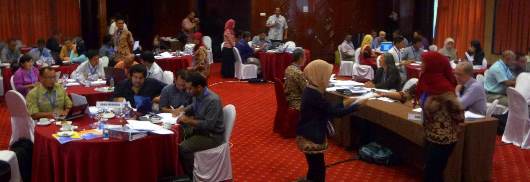
The participants represented National Tsunami Warning Centres (NTWCs), Disaster Management Organisations (DMOs) and national media organisations. The workshop programme included plenary lecture sessions, breakout group work, and site visits to the BMKG tsunami warning centre, the National Disaster Management Centre (BNPB) and a national media organisation (Metro TV).
The primary objectives of the workshop were: to understand RTSP services and products; to understand the impact of the RTSP products on NTWC SOPs; to identify potential gaps and possible challenges for warning chain SOPs at the national level; to familiarise the electronic media with the RTSP service and develop/adapt SOPs for interfacing with the media; and to prepare for the IOWave14 Exercise, scheduled to take place in late 2014.
The tabletop exercise on the last day of the workshop provided the participants with an opportunity to put into practice what they had learned. The NTWC groups reported that they found it difficult to respond to requests for information during the first 30 minutes of the exercise. On the other hand, the DMOs commented that they wanted more information, more quickly from the NTWCs. The media groups commented that they wanted to receive more information faster and preferably at the same time or before sources of unofficial information.
The inclusion of national media organisations in this workshop was particularly enlightening as it exposed several potential gaps in the flow of information between the media and other stakeholders. This highlighted the need for the media to develop SOPs that are harmonised and coherent with the SOPs of other national organisations in the warning chain.
Funding for the workshop was provided from IOC Special Account funds contributed by the Government of Australia. It is planned to conduct a similar workshop for Western and Northern Indian Ocean countries in Hyderabad, India, in 2014.
Plus d'articles...
Le programme relatif aux tsunamis – ce qu’il est
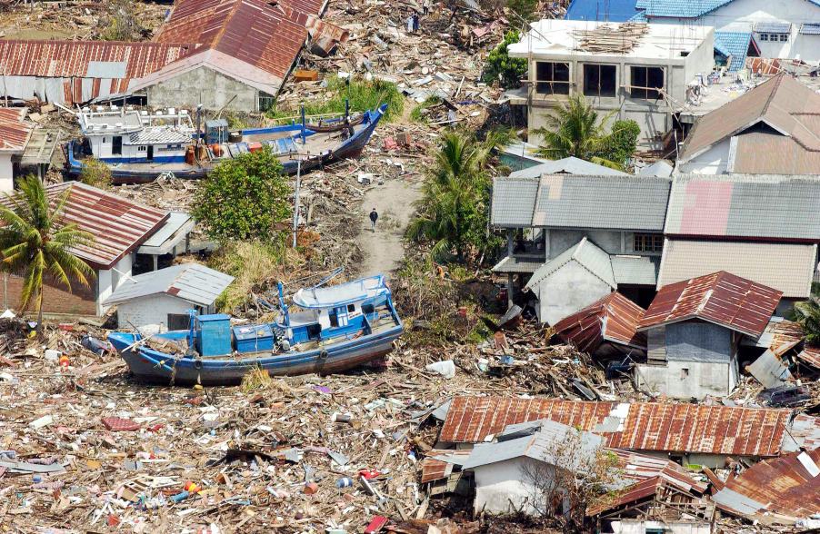
La côte indonésienne, entre Banda Aceh et Meulaboh, au lendemain du tremblement de terre et du tsunami du 26 décembre 2004. Photo Evan Schneider © UN Photo
L’UNESCO aide les États membres à renforcer leur capacité d’évaluation du risque de tsunami, à mettre en œuvre des systèmes d’alerte rapide aux tsunamis et à mieux préparer les populations exposées. Elle travaille étroitement avec les organismes nationaux et favorise la coopération
interorganismes et régionale. Des centres régionaux spécialisés fournissent une information relative aux tsunamis, laquelle, assortie d’une analyse nationale, constitue la base des alertes publiques. En outre, l’UNESCO encourage des démarches fondées sur les populations, à la base, par le biais de l’élaboration de plans d’intervention et de campagnes de sensibilisation qui impliquent fortement les établissements éducatifs et l’utilisateur final.
Upcoming Events
7 August 2024
19 August 2024
19 - 30 August 2024
Chile